A slow moving storm will bring rain to Carson City and surrounding counties along with high elevation Sierra snow Wednesday and Thursday, according to the National Weather Service.
A storm currently off California coast will begin a sharp change to a cooler and wetter weather pattern starting Tuesday, with the main impacts expected from late Wednesday morning through Thursday night, NWS forecasters said.
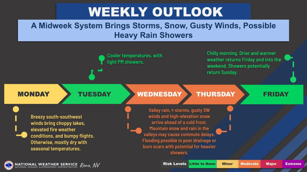
Today, Tuesday, we can expect the weather changes to begin with bands of light afternoon rain showers that will increase overnight into Wednesday.
Storm could bring 1-2 inches of rain to valley floor
Widespread rain is expected Wednesday, which could be locally heavy at times with the potential for small hail accumulations, NWS forecasters said. By Wednesday night into Thursday, a larger, wetter system will arrive, with rain and thunderstorms extending through Thursday across much of the region.
Temperatures will cool down as well, with highs mainly in the upper 40s to upper 50s, NWS forecasters said.
“While this rain will include beneficial impacts such as greatly reducing fire potential, recharging the waterways, and easing the dust buildup from an overall dry early fall, areas with more persistent heavier showers and storms could receive total rainfall of 1-2 inches for this 2-day event,” according to the weather service.
Forecasters advise the heavy rain may lead to flooding in poor drainage areas or on recent burn scars including the Hawk, Bull and Bug fires near Reno. Gutters and drains should be checked and cleared before the rain begins.
Motorists should watch for slick roads as oils and other vehicle fluid deposits combine with the rainfall, leading to slower commutes from Wednesday afternoon through Thursday, NWS forecasters advise.
Sierra snow to range from 2 to 4 inches, up to a foot for higher peaks
Meanwhile, for higher Sierra elevations (mainly above 8,000 to 8,500 feet), snow could impact higher passes and summits including Ebbetts, Tioga, Sonora, Carson and Mt Rose at times from Wednesday night through Thursday, according to NWS forecasters.
Snow amounts could range from 2 to 4 inches in the lower Sierra areas with higher-end scenarios producing up to a foot of snow for higher peaks of the Sierra crest and White Mountains in Mono County, according to the weather service.
The storm system should leave the area by Friday, bringing overall dry and cool conditions through the weekend, with highs mainly in the mid-upper 50s in the Sierra and mid-60s for lower valleys.