As Memorial Day arrives with sunny skies and warm conditions, a cold front moving into the region will drop temperatures around Carson City and surrounding counties this week, bringing gusty winds, potential thunderstorms and even some snow in the higher elevations of the Sierra around Lake Tahoe.
Monday will bring valley temperatures in the low 80s and 70s around Lake Tahoe.
However, as the spring storm approaches, southwest to west winds will ramp up with gusts 35 mph to 45 mph Monday afternoon and evening especially in areas from US-50 northward, prompting a Lake Wind Advisory for Carson City and surrounding counties and a Red Flag Warning for northern Washoe County and eastern Lassen County in California.
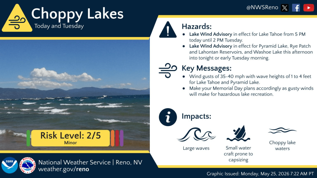
The National Weather Service advises folks to be aware of these winds if planning lake recreation, as relatively calm conditions earlier Monday will become much more hazardous as the day progresses. Meanwhile, patchy blowing dust could reduce visibility downwind of desert sinks and playas in parts of northwest Nevada.
For the Sierra, the strongest ridge winds (peak gusts 75-85 mph) are expected to arrive Monday night into Tuesday morning as the cold front associated with the incoming storm edges closer. While a few showers and brief thunderstorms may pop up in the afternoon in parts of Mono and southern Mineral and Lyon counties, this potential is lower (10-20 percent chance) compared to recent days, according to the National Weather Service.
Much cooler and windy as cold front pushes into region
For Tuesday, high temperatures will be 15 to 25 degrees cooler from US-50 northward and 5 to 15 degrees cooler south of US-50 as the cold front pushes southward, NWS forecasters said. The most likely timing for the cold front passage is Tuesday morning for northwest Nevada, then clearing the I-80/US-50 corridors by midday to early afternoon and exiting southern Mono-Mineral counties later in the afternoon, forecasters said.
West winds will shift to northwest and produce gusts 30-40 mph across much of the region mainly from I-80 southward, leading to another day of choppy lake conditions, with patchy blowing dust potential shifting to parts of west central Nevada, forecasters said.
As the storm drops southward, shower chances will increase by Tuesday morning across northwest Nevada, and slowly advance southward to the Lake Tahoe Basin and far western Nevada by late Tuesday, and into west central Nevada Tuesday night. Isolated lightning is possible Tuesday afternoon.
Overall precipitation chances (40 to 70 percent) favor northeast California and northwest Nevada with a few locations potentially receiving 0.25-0.50 of an inch of rainfall. Otherwise, precipitation amounts are likely to be light and spotty, while snow levels around the Lake Tahoe Basin dip to near 6,500 to 7,000 feet by late Tuesday afternoon.
For Wednesday and Thursday, the upper low is projected to meander over the region, leading to increased precipitation and isolated thunder chances region-wide and the coolest temperatures of the week (highs in the 50s-lower 60s).
The locations receiving the most rain and higher elevation snow will be dependent on the eventual track of this low, but current weather models favor the eastern Sierra Wednesday afternoon and evening, then shifting to western Nevada and northeast California by Thursday, forecasters said.
Snow levels are forecast to bottom out around 6,000 to 6,500 feet Wednesday morning, then gradually rise to around 7,000 to 7,500 feet Wednesday afternoon and evening, climbing further Thursday as the low starts to move out of western Nevada, forecasters said.
Higher mountain passes across Mono and Alpine counties (Ebbetts, Sonora, Tioga) are at the most risk for light (up to 4 inches) but impactful snow accumulations and an inch or two over Mt. Rose Summit can’t be ruled out, forecasters note.
The main Tahoe area passes including Donner/Echo summits are less likely to see snow accumulate on roads, but a well placed precipitation band could produce brief slushy conditions especially in the morning or night hours on Wednesday. See NVroads.com for the latest travel conditions and updates.
Showers could linger into Friday, otherwise temperatures look to warm up closer to late May averages (upper 70s-near 80 for lower elevations/near 70 for Sierra communities) for the final weekend of May.